Hiking Near Safranbolu 2026: Tokatlı Canyon, Black Sea Ridges and Valley Walks
Book an experience
Things to do here
The top-rated tours and activities here — all with instant confirmation and free cancellation on most bookings.
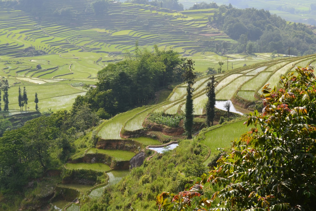
Safranbolu sits in a valley carved from the Black Sea mountain foothills — the surrounding landscape combines forested ridges, limestone gorges, and the plateau edges that drop dramatically toward the Black Sea coast. The hiking is not technically demanding but delivers excellent landscapes; the Tokatlı Canyon walk is one of the better gorge walks in northwestern Turkey.
Tokatlı Canyon (Tokatlı Kanyonu)
Distance from Safranbolu: 25km northwest. Trail distance: 7km one-way (Tokatlı Canyon floor trail); 3–4km for the most dramatic section. Duration: 3–5 hours for the full canyon walk (one-way with return transport); 2–3 hours for the dramatic lower section return circuit. Difficulty: Easy to moderate — canyon floor path, some scrambling on rock surfaces. Access: Car to Tokatlı village (25km); parking at the canyon entrance.
The Tokatlı Canyon is the primary hiking destination accessible from Safranbolu — a limestone gorge carved by the Araç Stream, with walls narrowing to 3–5 metres in the most dramatic sections and rising 50–100m above the water.
The walk: The trail follows the canyon floor, crossing the stream several times on stepping stones and simple wooden bridges. The canyon walls have cave formations — the erosion pattern has produced overhangs, solution caves, and rock faces with calcite deposits visible in the stone. The vegetation changes from the open valley mouth to the dense humidity of the narrow gorge interior — mosses, ferns, and deciduous trees (beech, hornbeam, maple) frame the canyon.
Best sections: The first 2–3km from the canyon entrance are the most dramatic — the walls are highest and the canyon narrowest here. The trail beyond opens somewhat; walking the entire 7km requires a return transport arrangement (or the same distance back).
Best season: April–June (spring flow in the stream; lush vegetation) and September–October (autumn colour; stream flow has reduced but is still present). Summer (July–August) is warm but manageable in the canyon shade. Winter walking requires waterproof footwear (stream crossings) and ice awareness on shaded rock.
Entry: No entrance fee. Practical: Wear shoes that can get wet — the stream crossings are unavoidable. A trekking pole is useful for the wet rock sections.
Gümüşköy ridge walk
Distance from Safranbolu: 10km southeast. Trail: Ridge and forest circuit (5–8km, 3–4 hours). Terrain: Forest path through oak and beech; some elevation gain (200–300m).
The forested ridge southeast of Safranbolu toward the Gümüşköy area provides local walking with views back toward the Ottoman town in the valley below. This is an early-morning or late-afternoon walk rather than a destination in its own right — the Ottoman silhouette of the Çarşı visible from the ridge viewpoints justifies the effort.
Best timing: Morning (07:00–09:00) for the light on the Çarşı roofline from above; October for the beech and maple autumn colour.
Yörük Köyü and plateau walks
Distance: 15km east.
The plateau around Yörük Köyü (the preserved Yoruk village) has open walking terrain — plateau meadows, remnant orchard land, and the specific landscape of the Black Sea mountain hinterland.
Character: Flat to gently rolling; agricultural; atmospheric in spring (wildflowers, fruit blossoms) and autumn (harvest activity visible in the orchards).
Village circuit: A 3–5km circuit connecting Yörük Köyü to the surrounding orchards and back — combine with a visit to the village itself (stone houses, traditional animal husbandry). 1.5–2.5 hours.
İlgaz Mountains (day trip)
Distance: 100km southeast (Kastamonu province). Access: Car (1.5 hours). Terrain: Sub-alpine meadows and forest; İlgaz summit 1,870m.
The İlgaz range — one of the significant mountain massifs of the western Black Sea hinterland — has marked trail networks and several accessible day hike options from the forest roads.
Ilgaz Mountain National Park: The national park (Ilgaz Dağı Milli Parkı) has a ski resort (operational winter) and summer hiking infrastructure. The summit ridge (1,870m) is accessible by a combination of forest road and trail (5–7km from the main forest road, 3–4 hours). Views from the summit extend to the Black Sea coastline on clear days.
Forest walks: Lower-altitude forest circuits (800–1,200m) in the beech and fir zone — gentler terrain, good for families and those avoiding significant elevation gain.
Best season: June–October for summer hiking; the summit can hold snow into May.
Kastamonu day trip (combined with hiking)
Distance: 95km southeast.
Kastamonu city — the provincial capital — has its own Ottoman heritage (Kastamonu Castle, Ottoman mosque complex, the Nasrullah Mosque) and is the gateway to the İlgaz Mountains and the Küre Mountains National Park.
Küre Mountains (Küre Dağları): A second mountain national park (UNESCO Biosphere Reserve, 2000) accessible from Kastamonu — more remote and less visited than İlgaz, with deeper gorges and longer trail networks. The Çangal Canyon and the Black Sea descent trails are the most impressive; these require more planning than a simple day trip from Safranbolu.
Practical notes
Water: The Tokatlı Canyon has stream water (not reliably safe to drink without filtration); the plateau and ridge walks have no water sources. Carry 1.5–2 litres/person.
Car requirement: Tokatlı Canyon and the İlgaz Mountains require a car. Rent-a-car is not available in Safranbolu itself — rent in Karabük (12km) or Ankara (220km) and drive in.
Weather: The Black Sea hinterland has more precipitation than the interior Anatolian plateau — rain is possible even in summer; waterproof layers are recommended for multi-hour walks.
Trail marking: The Tokatlı Canyon path is well-worn and easy to follow. The ridge walks around Safranbolu are less formally marked; a downloaded offline map (Maps.me or Wikiloc) is the practical navigation tool.
Day hike summary
| Route | Distance | Duration | Access | Best for |
|---|---|---|---|---|
| Tokatlı Canyon | 7km (3km for best section) | 3–5 hrs | Car (25km) | Gorge landscape, photography |
| Gümüşköy ridge | 5–8km | 3–4 hrs | Car/foot (10km) | Morning light, valley views |
| Yörük village plateau | 3–5km | 1.5–2.5 hrs | Car (15km) | Casual, village culture |
| İlgaz summit | 5–7km | 3–4 hrs | Car (100km) | Mountain views, national park |
Ready to explore?
Browse hundreds of tours and activities. Book securely with free cancellation on most options.
Browse on GetYourGuide →We may earn a small commission — at no extra cost to you.